

Since the summer of 2007, when Arctic ice extent hit an all time measured low, I have developed an ice watch fascination that generally sets in when the summer heat does in June.
The National Snow and Ice Data Center Sea Ice Index, provides a daily snapshot of the extent of ice in the Arctic Ocean. Both in map form and in a graph. The gray line is the average ice extent from 1979 to 2000, the green dotted line was the ice extent in 2007, the lowest ever measured. Right now, in June 2010 (blue line), the extent of Arctic ice is well below that of the recorded minimum from 2007 -- less ice, more open water, less reflected sunlight, more absorbed heat. This does not automatically mean that we will set a new record in 2010 for the smallest ice extent, because Arctic winds and storms can retard ice melting (and increase it); but a new record low ice extent does seem to be possible this year.
Friday, June 18, 2010
ice watch
Wednesday, December 23, 2009
dangerous beauty

Just before the power went out, I spent an hour tromping around documenting the snow fall. Notice how much snow is on the telephone and power lines!
This is the most snow we gotten since we've lived in eastern Kentucky (now 13 years). And its the second major snow before Christmas -- a highly unusual occurrence. For those in the know, this is just another example of the weather weirding that results form over all global warming. Here's the explanation:
The unprecedented melting of arctic sea ice the past two summers has undoubtedly had a significant impact on the early winter weather over the Northern Hemisphere. Several modeling studies presented at the December AGU meeting showed that sea ice melt on this scale is capable of injecting enough heat into the atmosphere to result in a major shift in the jet stream. Dr. Overland [Jim Overland of NOAA's Pacific Marine Environmental Laboratory] remarked that the early cold winter over North America this winter, and the exceptionally cold and snowy early winter in China last winter, were likely related to arctic sea ice loss. The sea ice loss induced a strong poleward flow of warm air over eastern Siberia, and a return flow of cold air from the Pole developed to compensate. Thus regions on either side of eastern Siberia--China and North America--have gotten unusually cold and snowy winters as a result. Source: Dr. Jeff Masters' WunderBlog
Not all signs of global warming are warmer days, instead what we see are important shifts and changes in the weather patterns.

Wednesday, August 20, 2008
What a difference a week makes
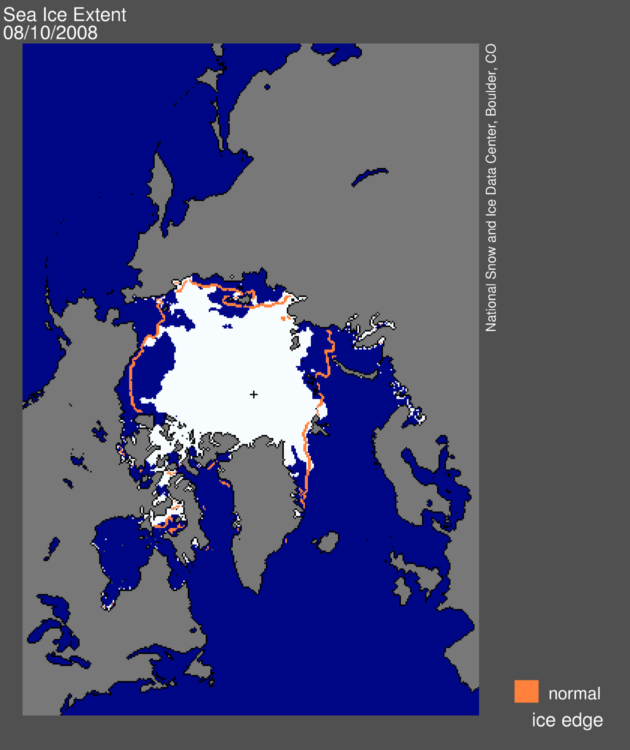
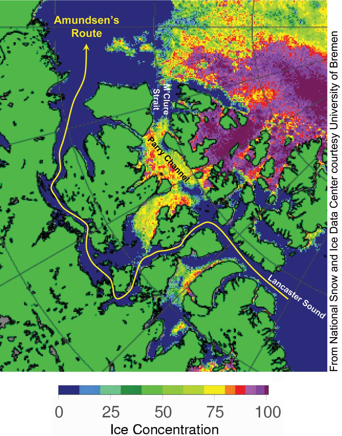
August 11, 2008
August 19, 2008 For the second year in a row the fabled Northwest Passage through the wide and deep water Parry Channel is ice free. The Parry Channel route is much farther north than the route taken with much difficulty by Amundsen in 1903 (see accompanying text at bottom of Arctic Sea Ice News page.
Anyone can follow the day-by-day changes in Arctic ice, and compare them to the satellite record back to 1979 at Arctic Sea Ice News and Analysis.
